What came before—and what never fully left
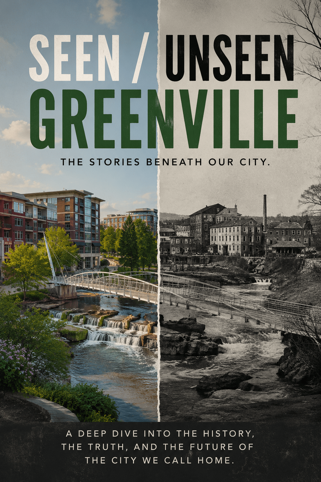
Greenville can feel like a new city.
A growing city.
A successful city.
A city figuring itself out in real time.
But that version of Greenville—the one most of us experience day to day—is only the latest layer.
What makes Greenville interesting isn’t just what it is now.
It’s how many versions of the city still exist underneath it.
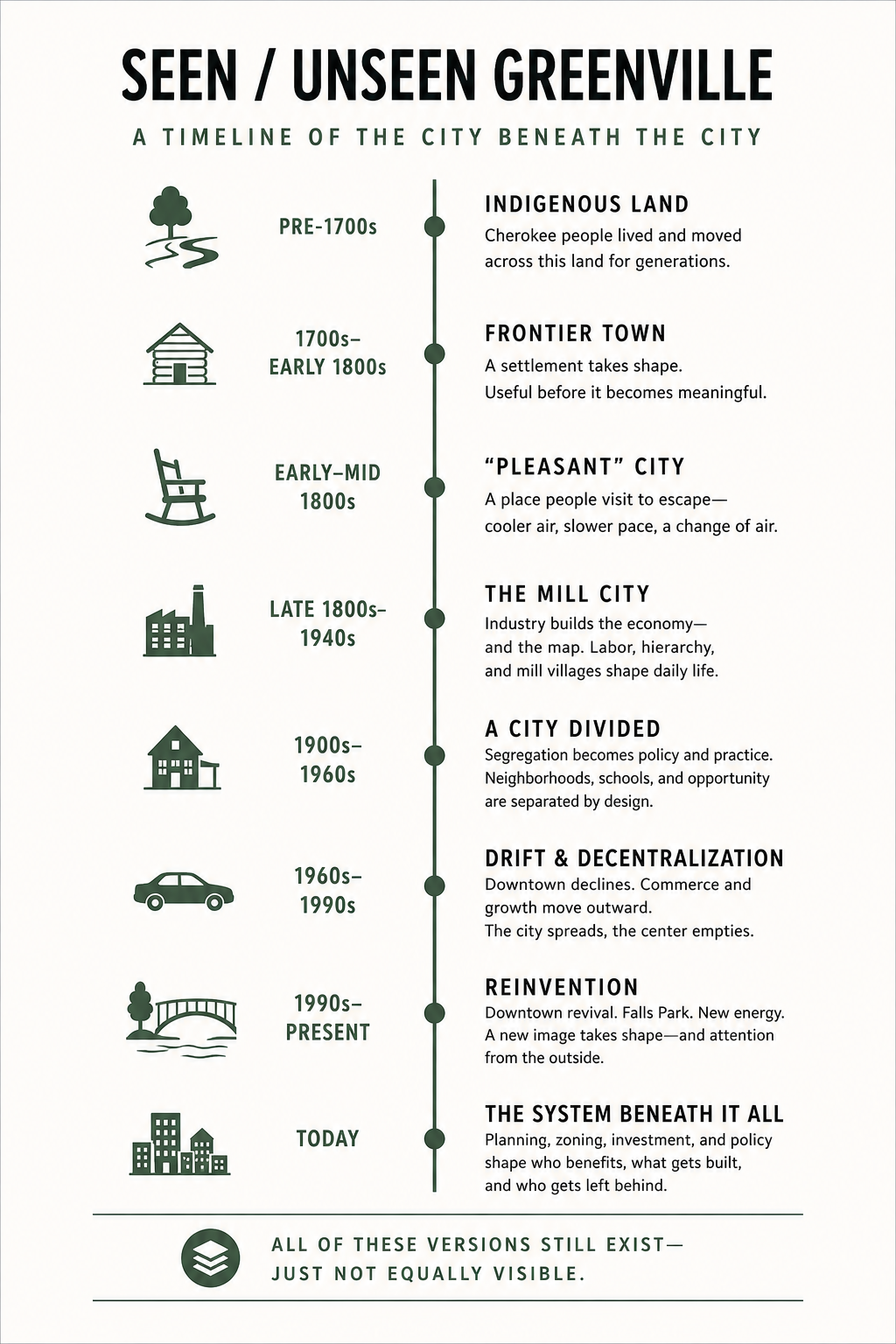
This timeline isn’t meant to be exhaustive. It’s meant to help reveal the structure:
how the city formed,
how it changed,
and how those earlier versions still shape what we see today.
Because Greenville didn’t begin with us.
We arrived in the middle of something already in motion.
Before Greenville
(Pre-1700s)
The land before the city
Before Greenville had a name, this was part of a much larger Indigenous landscape.
The Cherokee knew this land well:
rivers as travel routes,
ridges as orientation,
paths formed by movement rather than property lines.
The Reedy River mattered long before Falls Park existed.
The foothills mattered long before they became scenic real estate.
Trade routes and hunting grounds crossed areas that would eventually become roads and neighborhoods.
This wasn’t empty land waiting to be developed.
It was already understood.
That version of the land didn’t disappear.
It was replaced.
And the geography that shaped it still shapes Greenville today.
Frontier Greenville
(1700s–Early 1800s)
A place becomes useful
After the Revolutionary War, Greenville began forming into something recognizable:
a courthouse town,
a regional stop,
a place where land could be claimed, measured, and organized.
Roads began following older travel corridors.
Small settlements formed near crossings and water access.
The area around the Reedy slowly became a center of trade and movement.
This is where a pattern begins:
Greenville becomes useful before it becomes meaningful.
People come because it works.
Because it connects.
Because it offers opportunity.
Identity comes later.
Revolutionary Greenville
(Late 1700s)
A region divided before it was unified
The Revolutionary War touched the Upstate differently than many people realize.
This wasn’t just patriotic unity.
The backcountry was divided:
Patriots,
Loyalists,
farmers trying to survive,
families caught between sides.
Violence in the region could be deeply personal.
Neighbor against neighbor.
Settlement against settlement.
The war helped shape the early identity of the Upstate:
suspicious of centralized power,
fiercely independent,
and deeply tied to land ownership and self-determination.
Even early on, Greenville inherited a tension that still exists today:
local identity versus outside control.
The “Pleasant” City
(Early–Mid 1800s)
Greenville as escape
By the 1800s, Greenville had developed a reputation as a place people went to get away.
Wealthier families from Charleston and the Lowcountry traveled here during hotter months seeking:
cooler air,
fewer diseases,
and a slower pace.
The area became associated with health, retreat, and comfort.
The idea of Greenville as a “pleasant” place to live was born here.
That identity never really disappeared.
It just evolved into modern language:
“quality of life”
“best places to live”
“hidden gem”
“family friendly”
Even now, Greenville often sells itself less as an industrial powerhouse and more as a lifestyle.
That has deep roots.
The Mill City
(Late 1800s–1940s)
The system that built the map
The textile era transformed Greenville.
Mills weren’t just factories.
They were systems.
Places like Monaghan, Judson, Brandon, Dunean, and Poe Mill created entire ecosystems around labor:
housing,
stores,
schools,
churches,
and social life.
Mill villages shaped where people lived and how they lived.
Economic hierarchy became geographic.
Some areas gained stability and investment.
Others did not.
The textile industry didn’t just create jobs.
It created structure.
And even after many mills closed or disappeared:
the roads,
the neighborhoods,
and the invisible boundaries often remained.
A surprising amount of modern Greenville still follows the map laid down during the mill era.
Greenville and the Civil War
(1860s)
A Southern identity hardens
By the Civil War era, Greenville had become firmly tied to the economy and political identity of the South.
The war reshaped the region economically and psychologically.
Losses,
reconstruction,
racial tensions,
and economic instability all left long shadows.
After the war, the textile industry helped rebuild parts of the Upstate economy.
At the same time, systems of segregation and racial hierarchy became even more deeply embedded into civic life.
Many of the cultural narratives Greenville still wrestles with today—
Southern identity,
historical memory,
who gets remembered,
and who gets erased—
grew stronger during this period.
The Civil War didn’t just pass through Greenville.
It helped define the emotional and political architecture that followed.
A City Divided
(Early 1900s–1960s)
Segregation made visible—and invisible
Segregation in Greenville wasn’t just social.
It was structural.
Neighborhoods developed along racial and economic lines.
Schools reflected those divisions.
Investment reflected those divisions.
Communities like Nicholtown and Sterling were shaped by those realities, not by accident but by policy, economics, and long-term patterns of exclusion.
Even infrastructure decisions reinforced separation.
And like many American cities, Greenville often removed or neglected communities in the name of “progress” or redevelopment.
When legal segregation ended, the underlying systems didn’t simply vanish.
The patterns adapted.
Some neighborhoods received investment.
Others continued carrying decades of disinvestment forward.
If you look closely enough at Greenville today—at school outcomes, property values, transportation access, or development pressure—you can still see echoes of those earlier decisions.
Not always openly.
But visibly.
Drift and Decentralization
(1960s–1990s)
When the city lost its center
Like many American cities in the postwar era, Greenville began spreading outward.
Downtown declined.
Shopping centers and commercial corridors expanded.
Cars reshaped daily life.
McAlister Square became a regional centerpiece.
Laurens Road exploded with dealerships, restaurants, and retail.
Haywood Road and eventually Haywood Mall became major economic anchors.
White Horse Road developed its own commercial identity.
Then Woodruff Road emerged and gradually pulled even more energy outward.
The city didn’t stop functioning.
It just decentralized.
Greenville became less about one center and more about a collection of corridors, pockets, and expanding suburbs.
That version of Greenville shaped how many longtime residents still experience the city today.
Not through downtown.
But through movement.
Vietnam, Conservatism, and the Modern Political City
(1960s–1980s)
Greenville during cultural realignment
As America changed during the Vietnam era, Greenville changed with it.
Like much of the South, the Upstate experienced major political and cultural shifts:
civil rights battles,
white flight,
religious conservatism,
anti-government sentiment,
Cold War patriotism,
and reactions against the social upheaval of the 1960s.
Factories still mattered.
Churches still mattered.
Patriotism still mattered.
But the country around Greenville was changing rapidly.
For some people, Greenville represented stability and tradition.
For others, it represented systems that resisted change.
This era helped shape the modern political identity of the region:
business-friendly,
socially conservative,
skeptical of outsiders,
but also deeply invested in growth and self-reinvention.
A lot of modern Greenville’s contradictions emerge here:
a city that wants rapid progress,
while also wanting to preserve older identities and power structures.
Reinvention
(1990s–Present)
The Greenville most people recognize
Then came the Greenville most outsiders now recognize.
The downtown revival.
Falls Park.
Main Street redevelopment.
National rankings.
Tourism campaigns.
Restaurants.
Events.
Condos.
Walkability.
And to be clear:
This worked.
Greenville successfully reinvented itself in ways many Southern cities never fully managed.
The city became desirable.
But this version of Greenville didn’t erase the older ones.
It layered on top of them.
The old mill systems still affect neighborhoods.
Older development patterns still shape traffic and infrastructure.
Historic divisions still influence opportunity and investment.
The new Greenville exists beside the older Greenville—not separate from it.
The System Today
What the city rewards—and what it resists
Modern Greenville is still shaped by systems:
planning decisions,
zoning,
development incentives,
infrastructure priorities,
economic relationships,
and political influence.
Questions like:
What gets built?
Where does investment go?
Who gets protected?
Who gets displaced?
What kinds of growth are encouraged?
…aren’t new questions.
They are continuations of older ones.
Sometimes updated.
Rarely erased.
You can see it in debates about:
housing,
short-term rentals,
homelessness,
corridor redevelopment,
transportation,
downtown expansion,
and what kinds of businesses or projects receive support.
Every city evolves.
But no city evolves neutrally.
What This Timeline Reveals
If you step back, a pattern emerges:
Greenville is always becoming something new—
but never fully leaves its older versions behind.
Growth is rarely evenly distributed.
Every era creates winners and overlooked spaces.
The map persists.
Where people live—and what happens there—usually has history behind it.
And the story cities tell about themselves is often selective.
We celebrate what was built.
We talk less about what was displaced,
absorbed,
or carried quietly forward.
Why This Matters
Because what we see in Greenville today isn’t random.
Development patterns.
School outcomes.
Neighborhood identity.
Growth pressure.
Traffic.
Investment.
Displacement.
Revitalization.
All of it has roots.
And if we don’t understand those roots:
we mistake patterns for accidents,
and repetition for coincidence.
Understanding a city means understanding the layers underneath it.
Not just the version currently being marketed.
Final Thought
Greenville didn’t begin with us.
And it didn’t become what it is in one clean step.
It became this through layers:
land,
movement,
labor,
division,
reinvention,
ambition,
conflict,
and memory.
All of it still here.
Just not always visible.
And Greenville is still changing.
The questions now are:
What kind of city does it want to become?
Who benefits from that future?
What parts of the older Greenville survive the transition?
And what gets paved over again?
Those are the questions this project keeps circling.

Leave a comment